Excerpted from Rocked in Time, a work in progress.
Read More
Fifty-Four Hours*


Excerpted from Rocked in Time, a work in progress.
Read More
It was a June night of thunderstorms in central New Jersey
Read More

Two memories, perhaps not unique but important to my youth!
Living in Connecticut, we vacationed for two or three years at a “camp” on Great Pond of the Belfast Lakes in Maine. It was just my brother and I then, before another brother and a sister, so we loaded into the car and headed up Route 1 to Maine. Fond memories of stopping at gas stations and getting Coke in bottles out of the electric coolers – such a modern convenience. When we boys had to pee – no worries, just pull over to the shoulder and out we went to do our business! Favorite place to stop for meals was Howard Johnsons restaurants. We loved the HoJo’s grilled hot dogs (they toasted the buns in butter on the grill) and of course their ice cream. It was an all-day drive, but we never minded it.
In 1958, my Dad got a new job in Phoenix. By this time, brother #3 was a two-year-old toddler, and sister was a bun in the oven. After a one-week departure delay while I had the mumps, off we went in our dark green Pontiac station wagon. My toddler brother was in the back seat and my closet brother and I were placed in the “way back” on a blanket. There we roamed, played, slept and fought all the way across the country. Obviously before the interstate highways, we drove to St. Louis, where we continued west on Route 66 to Arizona. I came down with German measles in Missouri, so we spent a couple of extra nights in a motel while I was sick. I remember lying feverishly in bed and watching the “Motel” sign flash its neon message all night long.
Those were the days!

I come from a long line of family photographers. I love my family history and the information that is embedded in these old photos. I am fortunate to have some dating back many generations. I like to keep the tradition alive. The photo below is the oldest photo in my collection. It is undated, but based on the age of the sitters (my great grandparents) and type of clothing, I date it to the late 1800s. These are my father’s maternal grandparents. His grandfather was the root of the depressive gene and did not live into old age, unlike his wife, who will be seen again, surrounded by her five children.
My paternal great grandparents, Hannah and Samuel Prenksy.
My maternal grandmother, Belle Potoksky (changed to Perlis) Stein, and her oldest children, Anna and Joseph. I believe this is before they emigrated to this country, so taken about 1905.
My paternal grandfather’s family. Sam Sarason is standing, on the left, with the mustache. He died in 1943. Brother Ben had no children. On the right, brother Jacob has a son (also named Ken, like my father, named for the same grandfather) and a daughter Rae, who was a favorite cousin of my father’s. Sisters were Yetta, Pauline and Eevia Rifka, whose family ran the kosher dairy in St. Louis. Pauline’s husband worked with Sam, running the general stores in the MO, MS and AK territories.
My paternal grandmother’s family with elderly Hannah in the middle. From left to right, Joe, my grandmother Lizzie, Sarah (who had no children), Fannie, Meyer, who changed the family name from Prensky to Prentis in 1925, as he ascended in the corporate ranks in General Motors. This photo is from the early 1920s.
My father’s family, 1926. His parents in the center (Lizzie seated, Sam behind her, my 12 year old father, standing to left of his mother).
Dan’s mother’s family, the Bravers. His grandmother, Bessie and grandfather, Harry are the last two people in the second row on the right. Their three daughters seated in front of them. Dan’s mother, Gladys on the right, at the end of the row, beside her two sisters and young cousins. She was born in 1927, so this photo dates probably to 1932.
The Sarason family (with in-laws, Aunt Fannie, her husband and Uncle Meyer Prentis), gathered for their father’s funeral, November, 1943. My father is in uniform, in the center of the photo.

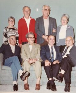
Sept, 1969, last photo of all 8 brothers and sisters. My father in front row with both hands on his legs.
My mother’s family at her engagement party, 1946.
Our wedding, June 16, 1974 surrounded by our parents.
Gladys Pfau’s 65th birthday party, surrounded by her five children, me and her two oldest grandchildren, September 12, 1992.
Sarason family at David’s bar mitzvah, Oct. 10, 1998.
Pfau family at David’s bar mitzvah, Oct. 10, 1998.
Dan’s parents’ 50th anniversary party, December 25, 1999.
Rachel Pfau’s bat mitzvah, December, 2009.
Sarason/Pfau family gathered after our mother’s funeral, August 17, 2010 (Vicki was in CA at her last week of her summer internship).
Pfau family gathered for nephew’s wedding, Sept, 18, 2021.