
The ferry, as the clouds break after a storm
To get to Martha’s Vineyard, an island in the Atlantic Ocean, 7 miles off the coast of Massachusetts, one must drive on various types of roads and take a scheduled ferry. It has been a tourist destination since the mid-1800s when people arrived by horse carts. Now there are highways for much of the drive.
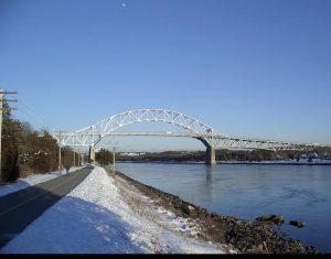
I live 90 miles from Woods Hole, where one drives to catch the ferry (the one to Nantucket leaves from Hyannis, further down the Cape). It is all highway until we reach the Bourne Bridge, built in the early 1930s, which connects the mainland to Cape Cod over the Cape Cod Canal, and is now in need of major repairs (deferred infrastructure). Once, when we had to pick up our children from school on the Friday of Memorial Day weekend, we encountered a 5 mile backup there. We missed our boat. Now, we can schedule our ferries (during peak times they are reservation-only) at times when we know we will not encounter traffic. We expect it to take between an hour and a half to two hours for the drive, depending on traffic.
Once across, we are on Cape Cod. It should be a half hour drive to the ferry, but we drop down, first to a 2 lane highway, then a lane of traffic in each direction, driving through the town of Falmouth, stop lights and all, a very busy place in summer months. Eventually, we take the right turn toward Woods Hole for the final 4 miles (and one traffic light) before the staging area for the Steamship Authority. We must arrive a half hour before our scheduled departure, as the boat comes in, unloads, then we load, get settled and go.
These days, with COVID, we tend to just stay in our car, but we don’t have to. There is seating on deck, and refreshments and WiFi available. The trip across takes 45 minutes. The Featured photo is the newest ferry – Island Home – seen as light broke out after a huge storm. We were the second to last car to get onto the boat that December day in the port of Vineyard Haven, having outlasted dozens who gave up their place in line. Ferries are cancelled in bad weather.
There are two ports on Martha’s Vineyard, both on the eastern end of the island, one in Vineyard Haven, which stays open year-round, as it is more sheltered from possible storms. Oak Bluffs is open during the busiest months of the season, but sits further east and is more exposed to the elements. Depending on traffic, it takes 15-20 minutes to get from the port to our home. The roads are not fast and can be quite congested with traffic. The road between Oak Bluffs and Edgartown drives along State Beach, a long, narrow strip, frequented by happy families, and famous for the “Jaws Bridge” under which the shark appears and attacks the swimmers. It is very busy during the summer.
The roads from the two towns converge at “the Triangle”, which now has the main Edgartown post office, a large hardware store, great meat market, pharmacy, parking; all the conveniences that moved out town over the past few decades as real estate became too expensive. It is a huge bottleneck. Traffic can back up for 20 or 30 minutes in August at that choke point.
Past there, it is one slow lane in each direction with lots of stores on each side of the road and traffic trying to enter from all sides. The main grocery story is a bit down the road on the left. This is Upper Main Street. There is also the main gas station in Edgartown on the left, so lots of cars dodging in and out.
Just beyond this point, the road splits again. Main Street continues on the left, but will become one way into the heart of the Village of Edgartown. The right fork is Cooke Street, a small, two-way street. Cannon Ball Park (a Civil War Memorial with canons and stack of balls) is in the center of the triangle formed by the divergence of the streets. I take Cooke Street to my house, as it is one way, and I cannot turn onto it from Main Street.
I pass an old cemetery, interesting to wander through, finding names on the headstones that are on the antique village homes and streets throughout the island. One cross street takes you up-island, toward the airport (just 10 minutes away), and beyond, toward the western part of the island, full of rolling hills, farms, larger estates, stone walls, exquisite views across glacial ponds and out to the ocean. People live there who want more land, solitude, don’t mind long drives to buy provisions or get to the ferry.
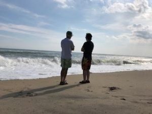
The next intersection brings one to Katama, the beachy area of Edgartown. South Beach, the huge, rolling south-facing beach is the main beach for the area. It is 3 miles from my home, not really walkable, but an easy drive. One more block, a left turn, and I am a block from my home, in the heart of the village of Edgartown. It is one-way, narrow street. There is some on-street parking. At some times of the day, people illegally park, making it difficult to turn into my driveway. It is fun to live where I do, but does have some inconveniences.
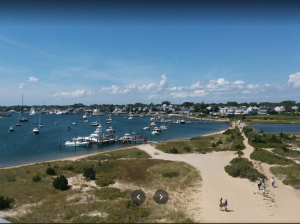
We are south of Main Street. North of Main Street, walking along North Water Street (all the streets are narrow, one way streets), one gets to the largest hotel on the island, the Harbor View, which looks out on the Edgartown Light House and its own beach, with a sandy path down. During the summer, the harbor is full of boats. One can sit all day, watching the activity in the harbor.
Katama, the “beachy” section of Edgartown, is full of wonderful homes as well. The friends who first brought us to the island, 35 years ago, live there. After visiting them twice, we rented in that section for four seasons before purchasing our home 25 years ago. We lived on a dirt road that was difficult to ride a bike off. Our friends live off Turkeyland Cove Road, which is where the Obamas bought a few years ago. They rented the house that season and purchased it in the autumn. It was the buzz of the island all summer.
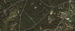
Overhead view of part of Katama where my friend lives (Loon Cove Way), and Obama, on Turkeyland Cove Road – dirt roads near Edgartown Great Pond
This past summer was Obama’s 60th birthday. He had planned to hold a big party for himself, but with COVID still running high, he scaled it back. There is a homeowner’s association and he sent a gift basket to everyone who lives in that area, including a handwritten note, begging their tolerance, saying it wouldn’t happen again for another decade. My friend appreciated the gesture. The area overlooks Edgartown Great Pond, a huge glacial pond, cut away as the glaciers receded. The area was developed a few decades ago, but remains quite secluded and the roads are still dirt (though our friend’s driveway is gravel). Francine has 5 acres of land and her own tennis court. She used to have a view out to water, but the trees have grown too tall over the years. It only takes us a few minutes to run back and forth between our homes, though they feel so different.
Retired from software sales long ago, two grown children. Theater major in college. Singer still, arts lover, involved in art museums locally (Greater Boston area). Originally from Detroit area.





Thanks for the terrific guide to your home, Betsy. No need for a GPS or Waze if we Retro pals decide to crah it. Actually, I am quite familiar with your route — and all the traffic problems one is likely to encounter — onto the Cape, though I’ve only taken the Vineyard Haven ferry to MV.
Seriously, a fun tour and delightfully told. And, as always, great pictures to illustrate it. Also a fun story about Obama’s birthday party. What a lovely gesture! Can you imagine Trump showing the same consideration at Mar-a-Lago? (Rhetorical question.)
Thanks, John. I know you have in-laws on the Vineyard, so can relate. The island has played host to three presidents (Grant was the first. He stayed in the Camp Ground in Oak Bluffs and said it was his best vacation ever). But Democrats come all the time for fundraisers. I heard Adam Schiff speak at a lecture series a few summer’s ago, before he decided that extorted Ukraine was an impeachable offense. Ernie Bock, Jr. inherited his father’s large estate, overlooking the harbor. He is a big Trump guy and TFG asked him to hold a fundraiser for him there during the summer of 2020. He, wisely, declined (unlike Dershowitz, who is persona non grata up in Chilmark now).
It takes a lot of time and good planning to get to your place on Martha’s Vineyard, but clearly it is worth the journey. Your pictures are lovely and add to the story of a long but interesting trip.
Yes, time and planning (I put in for my summer ferry reservations before leaving for London – they will be opened for processing on January 11)! Last summer was the busiest we had ever seen and getting a reservation became close to impossible without lots of planning and some cajoling (with Dan’s medical emergency, I was able to talk to supervisors who gave me priority reservations).
As people say, once you are on the ferry, all the troubles melt away.
Your story made me miss Cape Cod all over again. I have not been there that many times, but I remember each trip fondly; waving at Philippe Cousteau through a porthole of the Calypso at Woods Hole, diving off Race Point, buying a naughty T-shirt in P-Town, working as a fish identifier along the Canal in Bourne….
The Cape is a magical place!
You’ve mentioned some great spots on the Cape, Dave. It does have its own magic.
You must have made that trip many times—you know every twist and turn and stop along the way by heart. It is probably both aggravating and reassuring that there is no superhighway to take you to your lovely destination.
I have done the drive several times a year for 25 years, Khati. There is a bumper sticker that jokes about a bridge to the Vineyard. It would certainly change its character. The streets are so narrow that it fairly bursts with all the cars during August. Another bumper sticker says: “Pray for September”.
Love the Cape, Betsy, and now you’ve introduced me to the beauty (and traffic) of the Vineyard. Hope to get there one of these days. You win the award for the most detailed road description.
I wanted to give a sample of lots of different types of roads (and even methods of travel, like the ferry or bridge). Getting to and around the Vineyard gave me that opportunity, Mare. It is a beautiful, if heavily trafficked area.
Thanx for the vicarious Vineyard tour Betsy!
We’ve been on those Steamship Authority boats – we call them ferries to Paradise!
Happy to provide the vicarious joy, Dana. Yes, many people do call those ferries Paradise (or at least a trip thereto)!
Thanks for managing to sit down and write this wonderful travelogue right after coming back from your exciting time in London! Great to learn all the details involved in getting to the Vineyard. I’m hoping to come visit you in May – do I need to make a ferry reservation now? Or is that just for cars?
You can walk up and buy a passenger ticket at the terminal in Woods Hole just before you get on the boat, Suzy (give yourself a bit of time; like everywhere else, they are short-staffed, but have just imposed a vaccine mandate for all Steamship employees – YAY)! I know we’ll be in touch with potential dates before your visit.
You made that route sound attractively familiar, Betsy. I recently drove from Duxbury (often called DeLuxebury) to catch the Edgartown ferry. The two islands fascinate me, and I have very deep impressions of both Nantucket and Martha’s Vineyard. You brought back those recollections with your description. I probably have passed your home many times in and out of town to visit my friend, Paul Wales, who recently moved back to Duxbury and sold his beautiful place. But now I have a new excuse! I can visit you! Hooray!
So you know the route, Charlie…not very difficult and quite close to Duxbury (which is a nice town, recently in the news for using anti-Semitic terminology for play calls for their football team)!
The two islands are quite different. Nantucket is much smaller, all one town, further away (a two hour ferry ride) and much more homogenous. It seems to matter a lot what one wears, what fundraisers one attends, who one knows, and is MUCH more Republican. They did hold fundraisers for the Orange Monster over there (never on our island). We are larger, have six different towns (each with its own government), and each with its own unique flavor, which we like. The topography is different from one end of the island to the other (it is 20 miles across). Increasingly, we embrace our indigenous and farming roots. We find it pleasant. Give me a holler the next time you are in the area.
Ahh, Martha’s Vineyard. An earthly paradise. I see “natural selection” at play in the unique culture that has developed on the island in differentiation from the mainland, not unlike Mozambique and Madagascar, or Jurassic Park and Costa Rica, or Manhattan and the Bronx. My friend has recently gone native, opting to reside in Edgartown year round; she seems to have adaptive genes, which resist isolation blues, and salt air bone chill, and contractors on benders.
Love your story. And thank you for, among other things, reminding me how much I miss Barack Obama.
Your friend must be hearty, Jon, as the island is so isolated in the winter; adaptive genes are necessary. There are many of us who miss Obama. At least some of us catch glimpses of him on the golf course. (I don’t play, my husband sends me photos by text when he sees him tee off.)
Jonathan, Have to weigh in as I too see the Vineyard as Paradise. We try to get there for a few weeks every year as Betsy knows, and was there that scandalous Bill-Hilary summer and that first lovely Obama summer – yeah, miss him too.
Please expand on your Manhattan/Bronx comment as I lay claim to both!
And we love it when Dana and Danny come, so we can have dinner with them.
Soon again I hope!!!